
São Teotónio Guide
Cliffs, fishing ports and trails on the Alentejo coast
1 selected
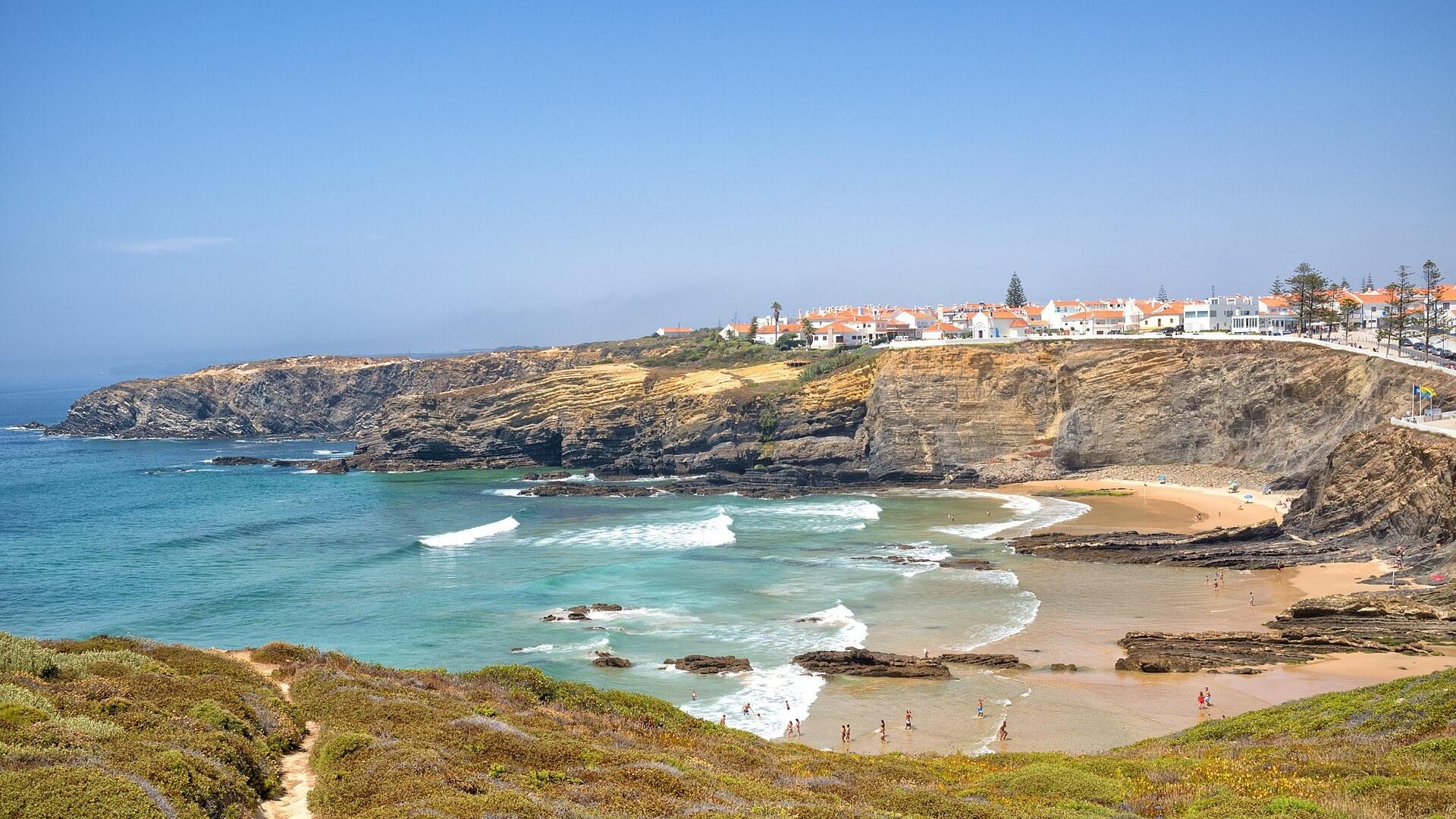
São Teotónio is a small town and parish on the coast of the Alentejo region in Portugal. It belongs to the municipality of Odemira, and its entire coastline is part of the Parque Natural do Sudoeste Alentejano e Costa Vicentina. The park covers 895.7 km2, of which 605.8 km2 is land and 289.9 km2 is sea.
Zambujeira do Mar is a village within the parish, on the western coast of the Alentejo, south of Cabo Sardão. Valleys, cliffs and faults cut through the landscape there, and small beaches of clear fine sand are scattered between them. Steep rock walls fall to little sandy coves wherever a stream reaches the sea. Outside the tourist season the area is almost deserted.
In Zambujeira do Mar stands the whitewashed Chapel of Nossa Senhora do Mar, dedicated to Our Lady of the Sea. It is a plain single-nave church and a protected monument, and you can walk onto its square. The historical fountains of Amores and Santa Catarina, in the same parish, count among the architecturally notable sights near São Teotónio. For the sunset over the Atlantic, head for the wall beside the cliff, the sea viewpoints or the beach itself.
North of Zambujeira do Mar, in the Odemira municipality, rises the Farol do Cabo Sardão lighthouse, one of the area's listed monuments. Cabo Sardão is also the only place in the world where storks nest on sea cliffs. Azenha do Mar, in São Teotónio parish, is a fishing port and village on the Odemira coast, and you can chat with the fishermen there. Four more small ports along the parish coast shelter fishing boats, in an area called Entradas da Barca.
Praia do Carvalhal lies a few kilometres from Zambujeira do Mar, at the end of a dirt track that starts just south of the village. The beach is broad rather than long and finishes in steep cliffs. Waves here are regularly strong, so surfers come, and both surf and bodyboard are practised. Summer is when the beach is most popular.
Closer to the village you will find the small, clear fine-sand beaches of Zambujeira, Alteirinhos, Nossa Senhora, Arquinha and Tonel. Praia dos Alteirinhos, to the south, allows naturism at its southern end. In 2025 the Odemira municipality had 11 beaches holding both the Blue Flag and Qualidade de Ouro status, among them the inland Santa Clara reservoir beach. The bathing season on Odemira's beaches in 2025 runs until 30 September. Lifeguards, bars, restaurants and parking are generally available, along with areas for surf, bodyboard, canoeing and stand-up paddle.
The Escola do Núcleo de Bodyboard da Zambujeira do Mar gives lessons and rents equipment on the well-known beach of Zambujeira do Mar. Elsewhere in the Odemira municipality you can surf and bodyboard at Malhão, Almograve and Milfontes. The Estação Náutica de Odemira has hubs in Vila Nova de Milfontes, Odemira and at the Santa Clara reservoir, with lessons in surf, bodyboard, stand-up paddle, kitesurf and foil. Horse riding is offered by Quinta das Bufardas and Moita Nova Equestre, and Hike Alentejo runs themed walks.
The Rota Vicentina is a sustainable tourism network between Santiago do Cacém and Lagos, with 750 km of walking trails and more than 1000 km of mountain bike routes. Its Caminho Histórico, the Historical Way, is 263 km long, split into 13 one-day stages, and rated easy. Autumn and spring suit it best, it is certified Leading Quality Trails, and it follows rural paths through the main towns and villages of the Odemira municipality.
The Trilho dos Pescadores, the Fishermen's Trail, runs 226.5 km in 13 stages between Sines and Lagos, with stages in Vila Nova de Milfontes and Zambujeira do Mar. It follows old paths to beaches and fishing spots. You walk along the cliffs through plenty of sand and wind, which makes it more demanding than the Historical Way. Walkers on this trail greet each other with Happy fishing, much like Bien Camino on the Camino de Santiago. The Rota Vicentina also lists 24 circular walks, nine of them in the Odemira municipality, each up to 16 km and taking two to six hours.
The Cyclin'Portugal Centre of Odemira has five high-tech bike stations, and São Teotónio is one of them. Cyclists can use pressure washing, bicycle maintenance and small repairs there, and ask for route information. The centre offers 38 mountain bike and gravel routes of over 1000 km, grouped in five hubs that include São Teotónio. Its Grande Travessia measures 144.5 km, passes through São Teotónio, ends in Santa Clara-a-Velha, and breaks into five stages of one day each. The touring bike route of the Rota Vicentina links the Lisbon and Faro airports in 10 stages of about 50 km, but it is not signposted.
Near Odemira, the Santa Clara reservoir beach holds a Blue Flag and Qualidade de Ouro status and offers boat trips, sailing, canoeing, stand-up paddle and sport fishing. Boat trips on the Mira river between Vila Nova de Milfontes and Odemira cover 40 km, including trips aboard the traditional boat Maresia do Mira. The Alentejo around São Teotónio is mostly agricultural, with wide horizons and soft hills.
Odemira covers 1720 km2 and is the largest municipality in Portugal by area. Its coastline is 55 km long, and about 44% of the municipality lies within the natural park and the Natura 2000 network. The park was created on 7 July 1988, and it has over 12 endemic plant species and several bird nesting sites.
Odemira is bordered to the north by Sines and Santiago do Cacém, to the east by Ourique, and to the south by Aljezur and Monchique. The municipality includes the fishing village of Zambujeira do Mar, with its fine sandy beaches and traditional architecture. The Alentejo is the warmest region in Portugal.
Saints, a fado singer and a parish that split and rejoined
São Teotónio has been an independent parish since the end of the 16th century, helped along by the 1580 stay of Teotónio de Bragança, Archbishop of Évora, who also pushed for the parish church to be built. The oldest document from the parish area is a mention of a church in São Teotónio in 1381. By 1532 the village, then known as Pé do Serro or Pé da Serra, was recorded with 22 families. A legend says Saint Theotonius, the first Portuguese saint, lived from 1082 to 1162 and passed through the village while it was still Moorish territory, converting its people to Christianity. In the 1960s the fado singer Amália Rodrigues had an estate with beach access built in Brejão, within the parish. Today it is the small hotel Herdade Amália Rodrigues. Murals on house walls in São Teotónio also commemorate her. Zambujeira do Mar takes its name from words meaning wild olive tree of the sea. It was separated from São Teotónio parish on 30 June 1989 and merged back on 29 September 2013. Farther afield, King Afonso III incorporated Odemira into the Crown and granted it a municipal charter on 28 March 1256, and King Manuel I renewed that charter in 1510. The Linha do Sul railway reached the Odemira municipality in 1888, though its stations lie in the east, away from the coast. Rural tourism began to develop in the Zambujeira do Mar parish in the last half of the 20th century, and tourism is now its principal activity, next to agriculture, cattle breeding and fishing. Odemira itself rests on two big activities, tourism and export-oriented agriculture, and by 2014 it produced 90% of Portugal's raspberries.
Alentejo wine and medronho around São Teotónio
São Teotónio lies in the Odemira municipality, whose gastronomy brings the flavours of the countryside and the sea to the table. Alentejo wines are very popular among the Portuguese. The local drink medronho is a strong liqueur made from the medronho fruit, and you should sip it rather than gulp it.
Reaching São Teotónio by road, bus and rail
São Teotónio sits about 6 km east of Zambujeira do Mar, the village in its parish that lies directly on the sea, 13 km southwest of Odemira. Odemira itself is about 100 km southwest of the district capital Beja and about 10 km east of the Atlantic coast. The national roads N123 and N263 cross Odemira and link the municipality to the IC1, 37 km away, and to the A2 motorway, about 60 km away. The nationwide Rede Expressos bus network serves Odemira. The Odemira municipality has two active railway stations on the Linha do Sul, Amoreiras-Odemira and Santa Clara-Saboia, and neither is in the town of Odemira. The Amoreiras-Odemira station is 22.8 km northeast of the town.
Cycling in and out of São Teotónio
São Teotónio is one of the bike stations of the Cyclin'Portugal Centre of Odemira, so cyclists find washing, maintenance and small repairs there. The Grande Travessia cycling route of 144.5 km connects the entry points of that centre. It starts at the Amoreiras-Gare or Funcheira railway stations and crosses São Teotónio.
Festivals, weather and timing for São Teotónio
São Teotónio is best known for its June festivals dedicated to the church's saints, when the village streets are decorated with paper flowers. At the climax, people ride decorated carts to the nearby coastal village of Zambujeira do Mar for a cleansing bath in the sea. When is the main festival season near Zambujeira do Mar? August is the main period of cultural activity in the Zambujeira do Mar parish. It brings the Festival do Sudoeste, the 15 August religious festival of Nossa Senhora do Mar and an annual fair on 29 August. How long does the Sudoeste festival last? It starts on the first Thursday of August and lasts four days, making it one of the biggest summer music festivals in Portugal. It has been held in the Zambujeira do Mar area since 1996. How cold does it get in winter? Zambujeira do Mar has winter minimum temperatures averaging 6°C in January. In the Odemira municipality winters are mild and rainy, with daytime temperatures around 16°C. How hot are the summers? Summer maxima in Zambujeira do Mar are around 25°C in July, August and September. At the Daroeiras station nearby, the mean daily maximum reaches 26.6°C in August. How much rain should I expect? At the Daroeiras station the average rainfall is 1.8 mm in July, against 92.3 mm in December. Odemira summers are dry and sunny. Is the area busy all year? Outside the tourist season the coast around Zambujeira do Mar is almost deserted. The Alentejo is generally hotter than other parts of Portugal, and the Historical Way is best walked in autumn and spring.
FAQ
What is covered in the São Teotónio guide?
Discover São Teotónio in Alentejo: the Zambujeira do Mar beaches, Rota Vicentina trails, fishing ports and June festivals. Plan your Portuguese coast trip. It includes 1 recommendations across 1 gallery.
Next →How many places are in the São Teotónio guide?
The São Teotónio guide lists 1 places: 1 gallery.
Next →Where is São Teotónio?
São Teotónio is in São Teotónio, Alentejo, Portugal (37.5115, -8.7072).
Next →How do you get to São Teotónio?
São Teotónio sits about 6 km east of Zambujeira do Mar, the village in its parish that lies directly on the sea, 13 km southwest of Odemira. Odemira itself is about 100 km southwest of the district capital Beja and about 10 km east of the Atlantic coast. The national roads N123 and N263 cross Odemira and link the m…
Next →What should you eat in São Teotónio?
São Teotónio lies in the Odemira municipality, whose gastronomy brings the flavours of the countryside and the sea to the table. Alentejo wines are very popular among the Portuguese. The local drink medronho is a strong liqueur made from the medronho fruit, and you should sip it rather than gulp it.
Next →Is there camping in São Teotónio?
No camping listings in this pack yet — we do not invent venues. Entries will appear once verified.
Next →Can you rent a bike in São Teotónio?
No bike rental listings in this pack yet. Verified shops will be added when available.
Next →What are recommended gallery in São Teotónio?
Highlighted gallery in the São Teotónio guide: Zambujeira do Mar.
Next →Highlighted places
- Zambujeira do Mar — The beach cove and cliffs of Zambujeira do Mar, a village in the parish of São Teotónio.
Explore on the map
Tap a pin to highlight its place card
All
1 spots
Recommended places
Gallery
1 · 1 selected
Zambujeira do Mar
gallery
Related guides
Browse nearby destinations
Atouguia da Baleia
Leiria, Portugal
A village named for whales, minutes from the Atlantic
Castelo Mendo Guide
Guarda, Portugal
A walled medieval village on Portugal's Spanish frontier

Castelo Novo Guide
Castelo Branco, Portugal
A granite village in the heart of the Gardunha
Ferrel Guide
Leiria, Portugal
A quiet village behind Baleal's beaches and Atlantic surf
Foz d'Égua Guide
Coimbra, Portugal
Two streams, a dam pool and schist bridges
Foz do Arelho Guide
Leiria, Portugal
Two beaches, one lagoon, one Atlantic coast, one easy village

Save these places to your list
Copy the spots you picked into your list — maps and notes included.