
Chiquián Guide
Mirror of the sky below the Huayhuash peaks
1 selected
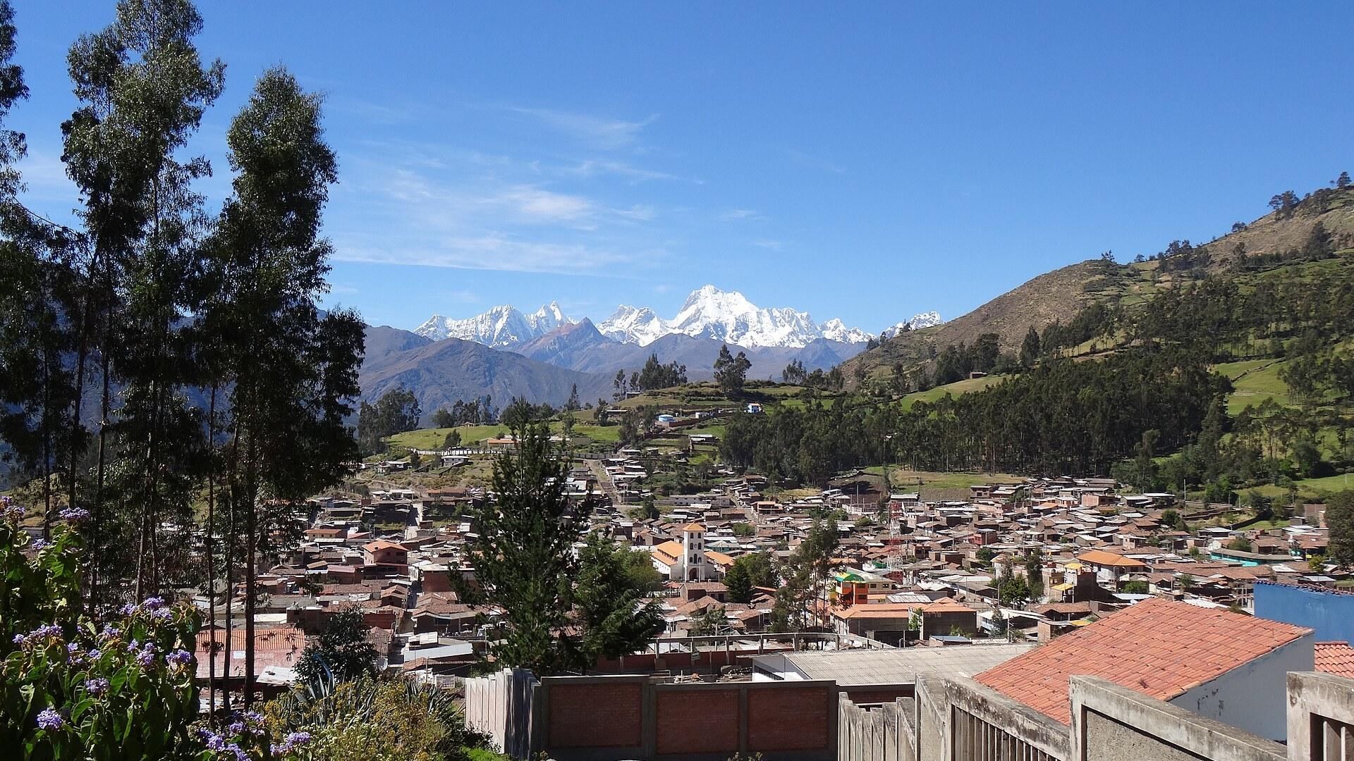
Chiquián is the capital of Bolognesi Province in the Áncash Region of Peru, and its nickname is the mirror of the sky. The town lies in a valley called the Valle de Pativilca, about 50 km south of the Cordillera Blanca. From Chiquián the snowy peaks Yerupajá, El Toro, Jirishanca and Rondoy close off the Pativilca valley to the north.
Close to town you will find a waterfall called Usgor, about 15 m high, and a seasonal hot spring. Day trips lead to a ruin town directly above Chiquián and to high pastures with vicuñas and vizcachas. Karkas has fields of mummies, and Llaclla has hot springs in the river. The Tambo called Castillo in Ticllos is another stop you can reach from Chiquián.
Huanoco viejo is a ruin town built in the style of Machu Picchu and at least 1,000 years old. Pachapaqui is the place where Puya raimondii grow. This is the world's biggest bromeliad: it grows between 3500 and 4700 m and flowers only once every 50 to 75 years. Whitewater trips on the river and free climbing near Karkas on the valley floor can also start from Chiquián.
The Cordillera Huayhuash is only about 30 km long from north to south, yet it counts seven peaks over 6000 m. It is famed for ice walls and for turquoise glacial lakes such as Jahuacocha, Siula, Carhuacocha and Sarapococha. Siula, at 6,344 m, became known through Joe Simpson's book Touching the Void. Condors, llamas, alpacas and viscachas can be seen in the range.
The Huayhuash Circuit is a challenging trek, rated harder than the Inca Trail, and it takes ten to fourteen days depending on the variant. Most of the circuit and most campsites lie above the 4,000 m tree line, and the Viconga campsite has hot springs. The Alpine Circuit around the peaks takes 8 to 10 days and includes some rock climbing and glacier travel. Yerupajá is one of the hardest Andean high peaks to climb, and its southwest face is the most popular route.
The main festival in Chiquián honours the patron saint Santa Rosa. It starts on 28 August and lasts eight days. A reenactment of the capture of the Inca Atahualpa opens it, and a bullfight closes it.
From 1903 Founding to Old Chiquián Ruins
Chiquián was founded on 22 October 1903 and received town status on 4 November 1908, and Bolognesi Province, of which it is the capital, was split off from Cajatambo in 1903. The province carries the name of Col. Francisco Bolognesi, the hero of the Battle of Arica. Simón Bolívar passed through Chiquián in 1824 while he prepared the battle of Junín. Antonio Raimondi (1826-1890) lived in Chiquián in the mid-19th century, exploring the area and describing new plant species. Luis Pardo, a Peruvian national hero sometimes called a Peruvian Robin Hood, came from Chiquián. Pastor Fink rebuilt the church of Chiquián after the great earthquake of 1972. In Huasta the old clay church still stands, with a colourful portal decorated with figures. Above Chiquián lie the ruins known as Old Chiquián or Wancar. Pucamachay near Aquia, Pueblo Viejo in Llamac and Marcará near Chiquián are open to visitors as well. Traditional houses in Chiquián were adobe buildings of one or two storeys, with deep eaves and carved wooden balconies. Streets are asphalted now, and brick construction is taking over. Patterned knitwear has made Chiquián famous since the 1970s and 1980s, and the local nuns still have alpaca wool sweaters made for sale in Europe.
Cheese, Pachamanca and Mote Around Chiquián
Food in Chiquián begins in the fields, where maize, potatoes and wheat are the main crops, with fruit by the river, wheat at 3,000 m and barley above 4,200 m. White cheese from Chiquián reaches shops as far away as Lima and Huaraz. The nearby village of Ocros is said to make the best cheese in the region. Pachamanca around Chiquián starts with stones heated in a fire. Meat seasoned with the herbs chinchú and ruda is layered on them with potatoes and sometimes oca and olluco, and a covering of earth lets the pile steam. A white maize with large grains is boiled with plant ash and water, then dried to become mote. Mote comes with every dish or goes into soups. A yellow, small-grained maize is cooked half-ripe on the cob in salted water and eaten with the typical local cheese. A brown-striped variety is roasted and salted as cancha. Huaraz is the bigger town for eating out. Cuy, or guinea pig, is a regional dish there, and on Sundays Jirón José Olaya hosts a street market where Picante de Cuy is served. The Mercado Central has a comedor on the second floor with a set meal of soup, rice and chicken, plus a vegetarian comedor, and the first floor suits stocking up for a trek. Huaraz also has several chifas, the Chinese-Peruvian restaurants. Restaurant Delfin, near the main plaza in Huaraz, is recommended for ceviche. Fuente de Salud serves cheap vegetarian food. Locals like La Brasa Roja for roasted chicken and burgers, and Creperie Patrick makes sweet and savory crêpes. The food markets of Huaraz are a good place to buy supplies for expeditions.
By Road from Lima and the Huaraz Bus Routes
Chiquián lies about 360 km north-east of Lima, roughly eight hours by road via the Panamericana, and the route crosses the Conococha Pass at 4080 m. Chiquián is the traditional gateway to the Cordillera Huayhuash. Many visitors treat it as a transit or starting point for trips into the Huayhuash or the Cordillera Blanca. For the Huayhuash Circuit it was long known as the Gateway to the Huayhuash. Daily colectivo buses now run to the village of Llamaq (3,300 m), and private transport reaches the Cuartelwain camp; both are the new trailheads for the circuit. The usual approach to Yerupajá runs south from Huaraz via Chiquián and Jahuacocha. Huaraz is approximately 8 hours by coach from Lima. Movil Tours, Ormeño, Cruz del Sur and CIAL are the bus companies recommended most often. Huaraz and Caraz are the usual bases for hiring camping and logistical support for the Huayhuash trek. Night buses leave Huaraz on a sealed road to Pativilca, where they meet the Panamerican Highway midway between Trujillo and Lima. Movil Tours runs the best night bus from Huaraz to Trujillo, a ride of about 7 hours, with Chinchaysuyo and Comite 14 next in line. The bus from Trujillo to Huaraz via Caraz and the Cañon del Pato needs about 8 hours on a rough, unsealed road and passes almost 40 tunnels. A day bus from Huaraz to Chimbote goes via the Callan Pass, Pariacoto and Casma (for Sechin); it is longer and rougher than the Cañon del Pato route. The airport of Huaraz is Comandante FAP Germán Arias Graziani Airport (ATA) at Anta, with only sporadic services.
Huaraz Combis, Taxis and Trail Starts
Chiquián lies in the Valle de Pativilca, and the local transport details here belong to Huaraz, a large town in the Cordillera Blanca region. Combis leave Huaraz for Caraz about every 20 min and stop at Carhuaz and Yungay on the way. Taxis in Huaraz are cheap and fast for getting around town. Women should avoid travelling alone in taxis at night. A 15 min collectivo (letter E or number 10) leaves from Mercado Central towards Chiwipampa, the start of the Laguna Wilcacocha trail. A combi from Huaraz reaches Catac, and from there a taxi collectivo runs to kilometer 131 on the road towards Conococha, where the trail to Hatun Machay begins. Combis from Fitzcarrald street run straight to the Monterrey thermal baths. Laguna Wilcacocha is a popular acclimatisation hike of 3.2 km with 500 m of elevation gain, taking 1.5 to 2 h up and 1 h down. Hatun Machay, the stone forest, is an easy 2 h walk up from the path at kilometer 131, and a refugio serves climbers. The Wilcahuaín ruin makes another acclimatisation hike: ride a combi uphill, then walk back along an old Inca trail in about 2 h. The Mirador de Rataquena above Huaraz is a 45 min walk to a lookout, though robberies have happened on the trail. Huaraz is the starting point for hikes to Laguna Churup, Laguna 69, Laguna Parón and the multi-day Santa Cruz Trek in Huascarán National Park. Homestays in Vicos (1 h from Huaraz) and Humacchuco (2 h from Huaraz) let visitors join Andean farming families, with hikes to the Huari and Recuay ruins and to Lake Llanganuco.
Weather, Safety and Trekking Tips for Chiquián
Chiquián has a rainy season from October to March, with heavy showers and fog that can sit in the valley all day. The rest of the year is dry with mostly sunny days, although July and August bring a short spell of clouds and brief showers. When is the best time for the Huayhuash? Trekking in the Cordillera Huayhuash almost always happens in the dry winter months from May to September. Chiquián gets almost no rain in June (0.9 mm) and July (0.2 mm), while March is the wettest month with 145.9 mm. How cold does it get? In the rainy season Chiquián has daytime temperatures of 12 to 18°C and nights below 10°C, close to freezing. In the dry season days reach up to 25°C and nights stay mostly above 10°C. Around Chiquián the contrast between sun and shade can reach 20°C in the dry season, and morning ground frosts are always possible. Is the Huayhuash safe? The Huayhuash area is considered generally safe today. The Shining Path guerrilla was defeated in 1992, and local communities began charging a fee for passing through private property. Near the north shore of Lake Viconga you can visit the remains of an old Shining Path base camp with a shooting range, barracks and a training field. What about altitude and Huaraz? Huaraz stands at 3100 m, so travellers arriving from Lima might need a day or two to acclimatise. In Huaraz it is not wise to travel alone at night or to carry much money at any one time. Captadores at the bus terminals steer arrivals to hostels that pay them commission, so ignore claims that your chosen hostel is full or far away. Which language will people speak? Spanish now dominates in Chiquián, and Quechua, specifically Chiquián-Quechua, is spoken almost only by older people. Outside the main tourist spots in Peru people often do not speak English, and punctuality should not be expected. The House of Guides (Casa de Guías) in Huaraz gives free information, sells maps and keeps a check-in/check-out book that trekkers without a guide should sign.
FAQ
What is covered in the Chiquián guide?
Plan your trip to Chiquián in Áncash, Peru: trailhead town for the Huayhuash Circuit, with pachamanca, local cheese, Santa Rosa festival and ruin day trips. It includes 1 recommendations across 1 gallery.
Next →How many places are in the Chiquián guide?
The Chiquián guide lists 1 places: 1 gallery.
Next →Where is Chiquián?
Chiquián is in Chiquián, Áncash, Peru (-10.1520, -77.1568).
Next →How do you get to Chiquián?
Chiquián lies about 360 km north-east of Lima, roughly eight hours by road via the Panamericana, and the route crosses the Conococha Pass at 4080 m. Chiquián is the traditional gateway to the Cordillera Huayhuash. Many visitors treat it as a transit or starting point for trips into the Huayhuash or the Cordillera B…
Next →What should you eat in Chiquián?
Food in Chiquián begins in the fields, where maize, potatoes and wheat are the main crops, with fruit by the river, wheat at 3,000 m and barley above 4,200 m. White cheese from Chiquián reaches shops as far away as Lima and Huaraz. The nearby village of Ocros is said to make the best cheese in the region. Pachamanc…
Next →Is there camping in Chiquián?
No camping listings in this pack yet — we do not invent venues. Entries will appear once verified.
Next →Can you rent a bike in Chiquián?
No bike rental listings in this pack yet. Verified shops will be added when available.
Next →What are recommended gallery in Chiquián?
Highlighted gallery in the Chiquián guide: Chiquián and the Cordillera Huayhuash.
Next →Highlighted places
- Chiquián and the Cordillera Huayhuash — The town of Chiquián in the foreground, with the snow-capped Cordillera Huayhuash in the distance.
Explore on the map
Tap a pin to highlight its place card
All
1 spots
Recommended places
Gallery
1 · 1 selected
Chiquián and the Cordillera Huayhuash
gallery
Related guides
Browse nearby destinations
Cabanaconde Guide
Arequipa, Peru
The village where Colca Canyon treks begin
Cotahuasi Guide
Arequipa, Peru
Gateway to one of the deepest canyons on earth
Paucartambo Guide
Cusco, Peru
Rival dance troupes, steep streets and a pass to Tres Cruces
Adrasan
Antalya, TR
A pine-backed bay where the days move slowly
Air Batang
Pahang, Malaysia
A car-free Tioman village for divers and walkers
Akyaka
Muğla, Türkiye
Azmak boats, kitesurf wind and wooden balconies

Save these places to your list
Copy the spots you picked into your list — maps and notes included.