
Peleng Island Guide
Lakes, caves and empty white beaches off Sulawesi
1 selected
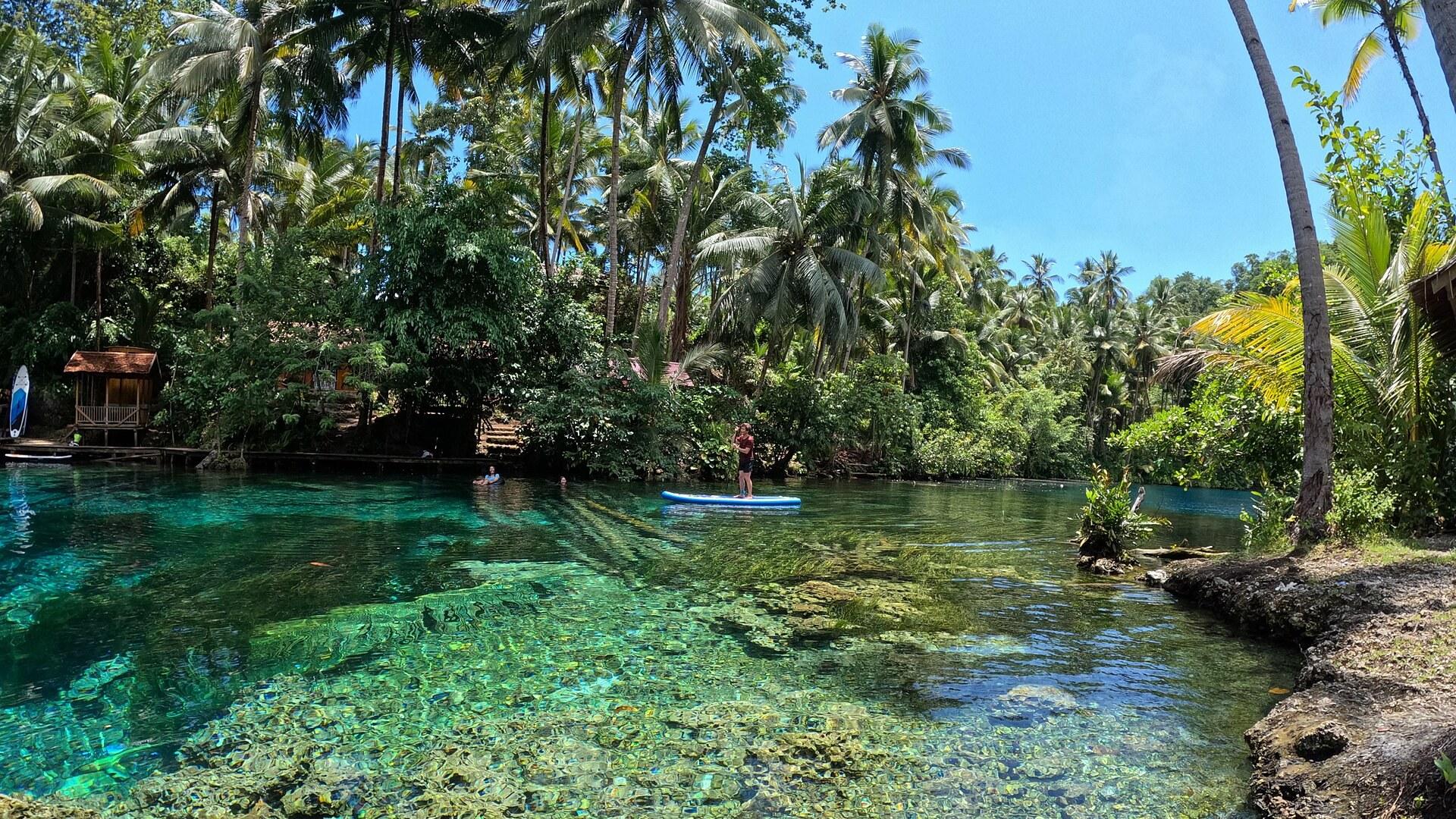
Peleng Island lies off the east coast of Sulawesi in Central Sulawesi, Indonesia, and it is the largest island of the Banggai Islands. The Banda Sea and the Molucca Sea surround it. Salakan is the largest city on the island, and the island is divided into 12 districts.
Tourism is still very underdeveloped here. The Banggai Islands are an escape from the tourist masses of Tana Toraja and the Togian Islands, and the scattered homestays have owners who all seem to know each other. Snorkelling and enjoying the empty beaches, lagoons and lakes are the main activities.
Paisu Pok Lake in Luk Panenteng village is famed on social media for its lush palm-tree setting and extremely transparent water. You enter through a wooden decorative gate. Next to it, Paisu Batango is a cyan lagoon where spring water mixes with sea water, and locals wash clothes there and fetch spring water.
Two caves hold very transparent turquoise and dark blue water. Gua Susundeng is the first, and Gua Bab'Banang is slightly smaller, very similar and a little better developed. On the coast, Tanjung Gundul is a cliff with a hole created by sea waves and a floor of sand-colored stones.
The beaches are white sand. Mandel Beach is long and well known but remote, with turquoise water. Oyama Beach has sand almost as fine as flour, while Bone Pompon, Poganda Beach and Long Beach are the ones with snorkelling.
The island is heavily forested and its bays that afford anchorage have reefs. In January 2020 the journal Science documented two new bird species and one subspecies from the mountains of Peleng, including the Peleng fantail. The Peleng tarsier is among the species found only in the Banggai Islands.
How Peleng Island became a regency of its own
Peleng Island owes its present administrative shape to two dates in the regency's history, one in 1999 and one in 2012. The Banggai Islands Regency was created on 4 October 1999 by splitting the Banggai Regency. On 14 December 2012 its southern districts were removed to form the Banggai Laut Regency, which left Peleng as the regency. A severe earthquake in spring 2000 caused considerable damage on the Banggai Islands, which include Peleng. The reduced regency now consists solely of Peleng, the most northern of the Banggai Islands. The Peleng Straits separate it from the mainland of Sulawesi. Salakan is the capital of the regency. Around the coast the regency also takes in some 440 small islands, and the largest are Bangkalan and Bakamanpauno off the north coast.
Eating on Peleng Island: homestay meals and local livelihoods
Eating on Peleng Island mostly happens where you sleep, because there are not many public restaurants on the Banggai Islands. Even in Salakan the options are somewhat limited. Homestays and accommodations usually provide three meals per day. Most people on Peleng Island make their living planting coconuts and sweet potatoes, or fishing.
From Luwuk to Peleng Island by boat
Peleng Island is reached by boat from Luwuk on Sulawesi, and as of March 2025 the closest airport is still Luwuk. Luwuk is linked to Sulawesi's flight and bus networks. A bus service runs via Luwuk with a boat or ship onward, and Merpati Nusantara Airlines once served the Banggai Islands from Palu, the capital of Central Sulawesi. Daily boats run from Luwuk to Leme-Leme on west Peleng at 14:00, and daily boats in the other direction leave Leme-Leme at 9:00. Similar daily boats serve the Luwuk to Salakan route on east Peleng, as well as Luwuk to Banggai on Banggai Laut. Twice a week, presumably Tuesday and Friday, a direct boat at 7:00 runs between Luk Panenteng, where Paisu Pok Lake lies, and Luwuk. Tickets cannot be bought online, and with some boat companies not even a day before departure, so show up at the pier a few hours before departure. The Peleng Strait is 12 km wide and separates the island from the Sulawesi mainland to the north and west. There seemed to be no flights to the new airport on Banggai Laut.
Roads, walks and boats between Peleng Island's lakes and beaches
Getting around Peleng Island means following the road to the lake, the caves and the northern beaches, and taking a small boat to the beaches of the east coast. Paisu Batango is a 10 min walk westward along the road from the Paisu Pok gate in Luk Panenteng village. Poganda Beach is 30 min by bike or car westward along the road from Paisu Pok Lake. The caves lie further out. Gua Susundeng is about 3 h clockwise by road around the western half of the island from Paisu Pok Lake, and Gua Bab'Banang is about 2.5 to 3 h in the same direction. From Salakan the north coast leads eastward. Mandel Beach is a 45 min drive along it and Bone Pompon is a 30 min drive. Oyama Beach, Long Beach and Tanjung Gundul on east Peleng can only be reached by boat, for example from Popisi or Lokotoy. At Tanjung Gundul the last 20 m can only be covered by swimming after the boat arrives.
Travelling on Peleng Island without a tourist infrastructure
Peleng Island and the other Banggai Islands are still very underdeveloped touristically, so travelling is a little harder without a guide or Indonesian language skills.
Weather, caves and beach conditions on Peleng Island: your questions
Peleng Island has a tropical rainforest climate in Salakan, with moderate rainfall from August to January and heavy rainfall from February to July. How much does it rain? Salakan gets an average of 1,750 mm of rain a year. June is the wettest month at 266 mm and October the driest at 71 mm. How warm is it? Mean daily maximums run between 30.1 C in July and 32.2 C in November. Mean daily minimums are 22.3 to 23.5 C. What happens to the caves when it rains? Gua Susundeng is closed when it rains because the paths are slippery. Gua Bab'Banang has a toilet, a changing room and better paths, so it stays open even when it rains. When is the best time of day for Paisu Pok Lake? The lake is best visited in the morning before local tourists arrive. Are there jellyfish? Long Beach next to Oyama may have seasonal jellyfish around the end of March. Seasonal jellyfish may also be in the water at Tanjung Gundul, so consider long-sleeved clothes and swimming shoes. Oyama Beach has no jellyfish, even at times when other places on the east side have them. What are the beach facilities like? Mandel Beach near Salakan has no infrastructure and a lot of trash lying around, though it can be cropped out of pictures. Oyama Beach also has some trash. At Bone Pompon showers are present, but depending on the season and water availability you may have to use the tubs in the bathrooms.
FAQ
What is covered in the Peleng Island guide?
Discover Peleng Island in Central Sulawesi, Indonesia: transparent lakes, turquoise caves, white sand beaches and daily boats from Luwuk. Plan your trip. It includes 1 recommendations across 1 gallery.
Next →How many places are in the Peleng Island guide?
The Peleng Island guide lists 1 places: 1 gallery.
Next →Where is Peleng Island?
Peleng Island is in Peleng Island, Central Sulawesi, Indonesia (-1.4000, 123.1670).
Next →How do you get to Peleng Island?
Peleng Island is reached by boat from Luwuk on Sulawesi, and as of March 2025 the closest airport is still Luwuk. Luwuk is linked to Sulawesi's flight and bus networks. A bus service runs via Luwuk with a boat or ship onward, and Merpati Nusantara Airlines once served the Banggai Islands from Palu, the capital of Ce…
Next →What should you eat in Peleng Island?
Eating on Peleng Island mostly happens where you sleep, because there are not many public restaurants on the Banggai Islands. Even in Salakan the options are somewhat limited. Homestays and accommodations usually provide three meals per day. Most people on Peleng Island make their living planting coconuts and sweet…
Next →Is there camping in Peleng Island?
No camping listings in this pack yet — we do not invent venues. Entries will appear once verified.
Next →Can you rent a bike in Peleng Island?
No bike rental listings in this pack yet. Verified shops will be added when available.
Next →What are recommended gallery in Peleng Island?
Highlighted gallery in the Peleng Island guide: Paisu Pok lake on Peleng.
Next →Highlighted places
- Paisu Pok lake on Peleng — A paddleboarder on the clear turquoise water of Paisu Pok lake on Peleng Island.
Explore on the map
Tap a pin to highlight its place card
All
1 spots
Recommended places
Gallery
1 · 1 selected
Paisu Pok lake on Peleng
gallery
Related guides
Browse nearby destinations

Karimun Besar Guide
Riau Islands, Indonesia
A ferry-hop port island near Singapore, temples and quiet beaches

Kayu Aro Guide
Jambi, Indonesia
A highland tea district at the foot of Sumatra's tallest volcano

Lake Maninjau Guide
West Sumatra, Indonesia
A crater lake reached by 44 hairpin bends
Pronojiwo Guide
East Java, Indonesia
Thousand waterfalls under Mount Semeru
Adrasan
Antalya, TR
A pine-backed bay where the days move slowly
Air Batang
Pahang, Malaysia
A car-free Tioman village for divers and walkers

Save these places to your list
Copy the spots you picked into your list — maps and notes included.