
Vermilion Guide
A small town on a great lake, with a harbor and a lighthouse
1 selected
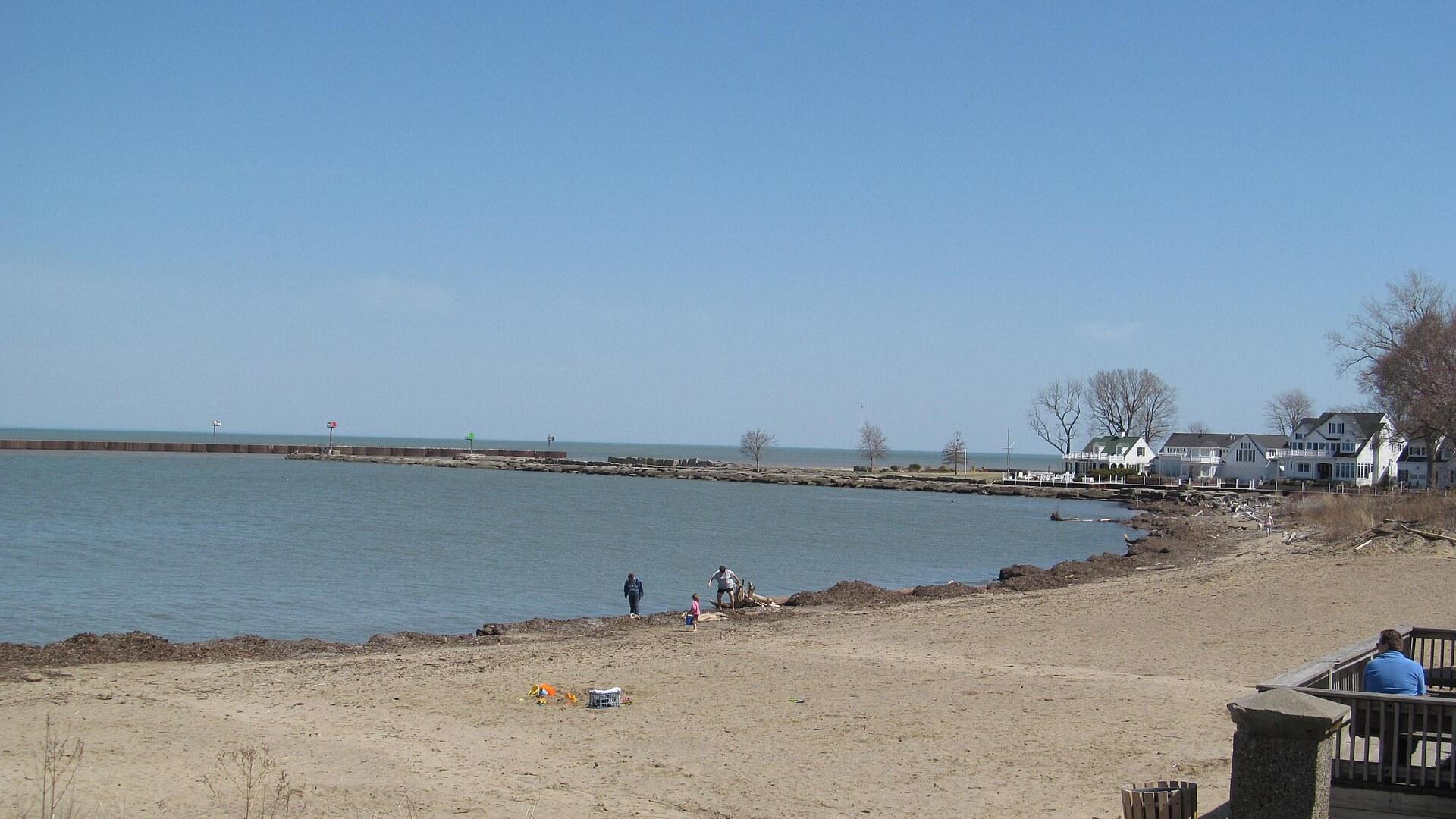
Vermilion, Ohio, in the United States, lies on the south shore of Lake Erie in Erie and Lorain counties. Its motto is “A Small Town on a Great Lake”, and the local nonprofit Friends of Harbor Town promotes its maritime roots under the slogan “Harbor Town 1837”.
Main Street has specialty shops, restaurants, art galleries and well-maintained captain's homes. Brummer's Homemade Chocolates is on Main Street, and near the lighthouse you also find The Artseen Gallery, Burning River Boutique and West River Paddling.
Main Street Beach is a public Lake Erie beach and small waterfront park with swimming, picnic tables, accessible facilities, an observation deck and public restrooms. A small replica lighthouse stands on the beach and marks the mouth of the river where it meets the lake. Inside is a 5th order Fresnel lens lit by a 200-watt bulb, and a live webcam streams lake views and sunsets from the beach.
The town has over 12 parks and facilities. The Vermilion River Reservation has the Bacon Woods and Mill Hollow areas on each side of the river, and the Mill Hollow-Bacon Woods Memorial Park is listed as a top attraction where a number of bird species can be spotted among the shale cliffs. The harbor offers sandy beaches, recreational boating, jet skis, canoeing and sailboats.
The Vermilion History Museum on Grand St illustrates 19th- and 20th-century letterpress printing and newspaper publishing in a building that was a print shop and weekly newspaper from 1905 to 1964. The News Print Shop Museum has two Linotype machines and four letter presses, plus an upstairs apartment with local artifacts and photographs.
The river itself shapes the town: it enters Lake Erie right here, and the marinas sit on it. A short distance before the lake it passes through a deep gorge, and the rest area on the westbound side of Route 2 has a short nature trail to an overview of the gorge. The river is commonly muddy after rains.
From a fishing harbor to the Village of Lake Captains
Vermilion was settled in the early 19th century and incorporated as a village in 1837, taking its name from the nearby Vermilion River. The river has been known by that name since at least 1760, when early European explorers named it after the purplish-red clay Native Americans used as body paint, the pigment vermillion. The Franks Site, a major archaeological site that was once a large village of the Erie tribe, sits atop the walls of the river gorge. The town developed as a fishing and small-boat harbor. Fishermen and sailors settled here because of the favourable location on Lake Erie, and in the 20th century shipbuilding and the fish trade became the main livelihoods. As larger nearby cities took over commerce, recreational boating became very popular on the river. Vermilion Harbor dates to about 1840 and is still a favorite port, with over 8,000 pleasure craft at the public docks and marinas. Many historic buildings survive, mostly the former homes of ship captains, and they are listed in the National Register of Historic Places. Vermilion was previously described as the “Village of Lake Captains”, with captains' homes in the Harbor Town Historic District in Victorian, Italianate, Arts and Crafts and Queen Anne styles. The Vermilion Lagoons neighborhood is one of the first planned residential communities on the water in the US, with construction starting in 1928. During the early 20th century the area became known as a resort community with many beaches and cottages, and many of these are still used as summer homes or vacation houses. During Prohibition, Vermilion was a sought-after spot for the illegal alcohol trade between the USA and Canada. In 1960 the town merged with the nearby village of Vermilion-on-the-Lake and became a city straddling Lorain and Erie counties. The lighthouse on Main Street Beach is a replica, raised in 1991 and dedicated in June 1992 as a recreation of the town's 1877 cast-iron pier light. A replica fifth-order Fresnel lens was installed during a 2016 re-lighting.
Where to eat and drink in Vermilion, from soda grill to cidery
Vermilion has over a dozen restaurants and eateries, including Old Prague Restaurant, Big Ed's Main Street Soda Grill, Martino's International Cafe and Chez Francois with Touche Wine & Martini Bar. Rudy's Bar and Grill offers a wide variety of beers, mixed drinks and bar food including homemade chips and hot sandwiches, with a variety of weekend entertainment. Romp's Dairy Dock on Liberty Ave is a dairy stand listed among the places to eat. A family-owned winery and cidery, operating since 2009, serves wines, hard cider and local craft beer. It has live music every Friday and Saturday evening year round and offers panini, pizzas, soup, salad and cheese plates. Seating is indoor and outdoor, with a fireplace inside and a fire pit outside. Leashed pets are allowed on the lawn, but no outside food or beverages are permitted. Around the lighthouse you find The Olive Scene, Lee's Landing and the Lake Erie Taphouse. For a quick lunch or dinner, the Vermilion Farm Market has a deli with items such as meatloaf, crab cakes and slaw.
Reaching Vermilion by road along Lake Erie
Vermilion is located on US-6 on the southern shore of Lake Erie and is easily accessible via the Ohio Turnpike (I-80/90) and State Route 2. The town lies about 55 km west of Cleveland and about 100 km east of Toledo, and Interstate 90 passes south of it. In miles, Vermilion is about 35 miles west of Cleveland and 17 miles east of Sandusky. There is no public airport nearby. Vermilion can also be reached by private boat.
Walking, golf carts and launch ramps in Vermilion
Vermilion's business district is walkable, and visitors can also rent a golf cart to get around. Gift shops, antique and specialty stores are mostly located close to each other, which makes shopping a very walkable activity. Boaters can use launch ramps and marinas including Bulan's Boatyard, Maple Grove Mairna, Valley Harbor Marina and Romp's Water Port & Dairy Dock. The Vermilion Municipal Docks launch ramp on W. River Rd. operates April to November, while Bulan's Boatyard offers restrooms and winter storage.
Launch ramp fees at the Vermilion docks
Two launch ramps in Vermilion list a ramp fee. The Vermilion Municipal Docks launch ramp charges a $6 ramp fee, and the Bulan's Boatyard ramp charges $5.
Festivals, river trips and where to stay near Vermilion
Vermilion's calendar revolves around the water and one caterpillar, so a few dates help when you plan a trip. When is the Woollybear Festival? It is a one-day event held on the last weekend of September or the first weekend of October. It centres on the woollybear caterpillar, whose rust-brown and black bands are folklore-predicted to indicate the severity of the coming winter. It draws over 150,000 visitors and includes the longest parade in Ohio. When is the Festival of the Fish? It is held on the third weekend of June as a three-day event each year. When does the Mystic Belle sail? The paddle-wheel boat tours the Vermilion River from Sandusky St, from June to September on Tuesday to Sunday at 14:00 and 16:00. A sunset trip runs on weekends only. Where can you stay? Lodging listed on Tripadvisor includes the Holiday Inn Express Vermilion and The Old Vermilion Jailhouse Bed and Breakfast. Can you fish the river? The Ohio Department of Natural Resources stocks the river with steelhead trout from fall through spring, and it is the westernmost river in Ohio stocked yearly with steelhead. It is also home to smallmouth bass, largemouth bass, rock bass, channel catfish, bluegill, crappie and freshwater drum.
FAQ
What is covered in the Vermilion guide?
Plan your trip to Vermilion, Ohio: Main Street Beach, the lighthouse replica, Mystic Belle paddle-wheel tours, the Woollybear Festival and harbor boating. It includes 1 recommendations across 1 gallery.
Next →How many places are in the Vermilion guide?
The Vermilion guide lists 1 places: 1 gallery.
Next →Where is Vermilion?
Vermilion is in Vermilion, Ohio, United States (41.4256, -82.3628).
Next →How do you get to Vermilion?
Vermilion is located on US-6 on the southern shore of Lake Erie and is easily accessible via the Ohio Turnpike (I-80/90) and State Route 2. The town lies about 55 km west of Cleveland and about 100 km east of Toledo, and Interstate 90 passes south of it. In miles, Vermilion is about 35 miles west of Cleveland and 1…
Next →What should you eat in Vermilion?
Vermilion has over a dozen restaurants and eateries, including Old Prague Restaurant, Big Ed's Main Street Soda Grill, Martino's International Cafe and Chez Francois with Touche Wine & Martini Bar. Rudy's Bar and Grill offers a wide variety of beers, mixed drinks and bar food including homemade chips and hot sandwi…
Next →Is there camping in Vermilion?
No camping listings in this pack yet — we do not invent venues. Entries will appear once verified.
Next →Can you rent a bike in Vermilion?
No bike rental listings in this pack yet. Verified shops will be added when available.
Next →What are recommended gallery in Vermilion?
Highlighted gallery in the Vermilion guide: The beach at Vermilion.
Next →Highlighted places
- The beach at Vermilion — The sandy beach at Vermilion on Lake Erie, with the harbour breakwater and lakeside houses beyond.
Explore on the map
Tap a pin to highlight its place card
All
1 spots
Recommended places
Gallery
1 · 1 selected
The beach at Vermilion
gallery
Related guides
Browse nearby destinations
Confluence Guide
Pennsylvania, United States
Where three waters meet on the Great Allegheny Passage
Crozet Guide
Virginia, United States
Vineyards, orchards and a railroad tunnel under the Blue Ridge
Ligonier Guide
Pennsylvania, United States
A frontier fort, a village green and the Laurel Highlands
Mazomanie Guide
Wisconsin, United States
Railroad depot, microcars and canoes on the Wisconsin River
Medicine Park Guide
Oklahoma, United States
Red cobblestones and creek streets in the Wichita Mountains
Occoquan Guide
Virginia, United States
A riverside artists' town on the Fall Line

Save these places to your list
Copy the spots you picked into your list — maps and notes included.