
Ramsau am Dachstein Guide
Walk and ski Nordic under the Dachstein south wall, not the Hallstatt shore
1 selected
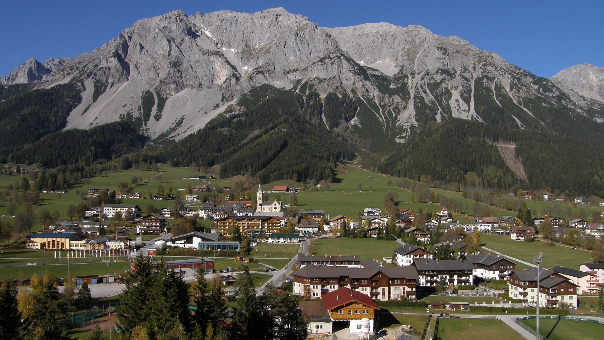
You are on the Styrian plateau under the Dachstein south wall, in the Liezen District, not in Hallstatt and not in a lake village of the kind you find in neighbouring Gosau. The same name covers the municipality and the high ground between the Dachstein range and the Enns valley. About 2,872 people lived here on 1 January 2026, with around 6,000 guest beds, which puts Ramsau among Styria's larger tourism communes. The postcode is 8972. The plateau itself sits between about 1,100 and 1,700 metres, immediately against the limestone face.
Hoher Dachstein rises to 2,995 metres, the highest point of Upper Austria and of Styria. The massif is strongly karstic limestone. Glaciers still sit on the north side. The Dachstein glacier is the easternmost glacier of the Alps, and the reddish south faces of Dachstein limestone stand about a kilometre high. From the north the massif reads as ice and rock. From here it drops almost vertically to the Enns valley floor.
You come to walk under that wall, to ski Nordic on the published loipes, or to stay in a tourism municipality that is still a working Styrian commune. Hallstatt, next door on the Upper Austrian side, has the lake postcard. Gosau, also next door, has the swim-lake image. Ramsau has pasture, larch, and a limestone face. The difference is geographic, not a ranking.
If the weather holds, one full day covers a village loop and a look at the south wall. Two or three nights fit if you walk the plateau and, in winter, use the Nordic tracks, which run over 100 kilometres. A week spent only on the plateau is a long stay unless snow is why you came. Fog does not turn the commune into a town of indoor museums.
The municipality is spread across six parts: the main village, Rössing, Hierzegg, Schildlehen, Leiten and Vorberg. You can walk a hamlet. You do not walk the whole plateau as if it were a high street. There is no railway on the plateau. Schladming is the neighbouring municipality in the Enns valley. Treat the last climb as a local bus, a taxi, or a car you have checked the week you travel.
If you want a lakeside promenade, look at Gosau or Hallstatt. If you want a quiet night under a big wall, the plateau works. Signal thins under limestone, so download a map before you walk toward the face.
History
A late Roman fortified settlement stood on the Knallwand. The first documentary mention is around 1120 as Ramsowe, from Old High German rams, ramsons, and ouwa, meadow. The largest historic landowners were Admont Abbey in the east and St Peter's Abbey in Salzburg in the west, at Schildlehen. On 1 August 1954 the municipality's name changed from Ramsau to Ramsau am Dachstein, so that it could be told from other Austrian places of the same name. Ramsau farmers were early Lutherans in Austria. From 1599 to 1781 the confession lived as secret Protestantism. After the Patent of Toleration in 1781, 127 of 130 families declared again for the evangelical faith. The 2001 census still gave 72 percent evangelical and 22 percent Catholic. That majority is unusual in Styria. Tourism as a recorded local economy starts with the opening of a hut at the foot of the south wall in 1880, now home to Styria's highest alpine museum. Georg and Franz Steiner made the first ascent of the Dachstein south wall in 1909. The south-wall cableway opened in 1969 and reached the glacier plateau. The 42nd Nordic World Ski Championships were held here in 1999. Since 2004 the municipality has been an official Luftkurort. A loden mill at Rössing appears in an Admont register in 1434, and it is still working, the oldest mill of its kind in Austria.
Eating
What opens follows an ordinary Styrian mountain pattern: soup, bread, a plate in season, coffee when a kitchen is running. A local split is theology as much as flour. So-called evangelical doughnuts are made of wheat, yeast and butter, and are often eaten sweet, because wheat grew on the sunnier Protestant plateau. Catholic doughnuts are made of rye without yeast or egg, more often savoury, from the shadier north slopes of the Niedere Tauern in the Catholic Enns valley. Treat that as folklore with a climate attached. A quiet Tuesday in January is a poor night to arrive hungry and expect a choice of tables. If you walk the plateau, take food with you.
Getting there
There is no railway station on the plateau. Schladming sits in the Enns valley as a neighbouring municipality. Further neighbours include Haus im Ennstal in Styria, and Gosau, Hallstatt and Obertraun in Upper Austria. The last kilometres are a climb onto a plateau between 1,100 and 1,700 metres. Confirm a bus, a taxi, or a car the week you travel. Road arrivals come up from the Enns corridor. In snow, that climb is the story. Check the road. Hallstatt's lake steamers and Gosau's lake shore belong to other municipalities on other sides of the massif. They will not put you on this plateau.
Getting around
Each hamlet is small enough to walk. The municipality is not. You do not need a bus to cross the main village. You do need a plan for the plateau: six parts, pasture tracks, and a limestone wall that is not a pavement. Alpine skiing in the commune sits around Rittisberg. The south-wall cableway opened in 1969. A car helps between Vorberg and Rössing. On a summer Saturday the same car is a queue. If a steep south-wall path or altitude around 1,500 metres is a problem, stay on the village lanes. The glacier is not a promenade. German is enough at the till. The local speech is Austro-Bavarian.
Money and connection
In Austria you pay in euro. Cards are ordinary in a tourism municipality of this size. Contactless is ordinary. Bring a card that works. Cash still helps in the hamlets. A July night under Dachstein is the dearer stay. A packed lunch and a day from a bed already paid in the Enns valley is the cheaper one. Plugs are Type F, 230 V. Emergency number 112. eSIM behaves as it does in the rest of high Styria: fine in the village, gone in a fold of karst. Café Wi-Fi is thin. Download an offline map before you walk toward the wall. Tap water in municipal Austria is generally drinkable. Do not drink from cattle troughs on the plateau.
When to go
You are on an alpine plateau, not in a lake season. Winter is when the Nordic tracks and the ski ground are what you came for. Summer is when the south wall is a walk rather than a slide. Shoulder months are quieter and colder at dawn. An avalanche from the Eiskar reached the edge of the settlement on 14 and 15 January 2019. Treat winter as mountain winter. The commune has belonged since 2021 to the multi-municipality tourism body Schladming-Dachstein. Cooperation also runs toward the Hallstatt Dachstein Salzkammergut world heritage region on the other side of the massif. UNESCO listed parts of that cultural landscape in 1997. That listing belongs to the region. It is not a reason to mix this plateau with Hallstatt's shore. Pay with a card. Stay off unmarked ice. The usual mistakes are treating the plateau as Hallstatt with cheaper beds, expecting a swim lake like Gosau, looking for a railway station in the municipality, starting a south-wall day at midday in cloud, and coming in November for a resort week with no snow plan. Ice, altitude, a white slope, and a missed last bus into the Enns valley are what you plan around.
FAQ
What is covered in the Ramsau am Dachstein guide?
Visit Ramsau am Dachstein: the Styrian plateau under Hoher Dachstein, hiking and Nordic tracks, a different night from Hallstatt or Gosau. Updated 2026. It includes 1 recommendations across 1 gallery.
Next →How many places are in the Ramsau am Dachstein guide?
The Ramsau am Dachstein guide lists 1 places: 1 gallery.
Next →Where is Ramsau am Dachstein?
Ramsau am Dachstein is in Styria, Austria (47.4218, 13.6531).
Next →How do you get to Ramsau am Dachstein?
There is no railway station on the plateau. Schladming sits in the Enns valley as a neighbouring municipality. Further neighbours include Haus im Ennstal in Styria, and Gosau, Hallstatt and Obertraun in Upper Austria. The last kilometres are a climb onto a plateau between 1,100 and 1,700 metres. Confirm a bus, a tax…
Next →What should you eat in Ramsau am Dachstein?
What opens follows an ordinary Styrian mountain pattern: soup, bread, a plate in season, coffee when a kitchen is running. A local split is theology as much as flour. So-called evangelical doughnuts are made of wheat, yeast and butter, and are often eaten sweet, because wheat grew on the sunnier Protestant plateau.…
Next →Is there camping in Ramsau am Dachstein?
No camping listings in this pack yet — we do not invent venues. Entries will appear once verified.
Next →Can you rent a bike in Ramsau am Dachstein?
No bike rental listings in this pack yet. Verified shops will be added when available.
Next →What are recommended gallery in Ramsau am Dachstein?
Highlighted gallery in the Ramsau am Dachstein guide: Dachstein plateau.
Next →Highlighted places
- Dachstein plateau — High pasture under the Dachstein south wall, Styria.
Explore on the map
Tap a pin to highlight its place card
All
1 spots
Recommended places
Gallery
1 · 1 selected
Dachstein plateau
gallery
Related guides
Browse nearby destinations
Dienten am Hochkönig Guide
Salzburg, Austria
Small hiking village under the Hochkönig, in Pinzgau
Filzmoos Guide
Salzburg, Austria
Dachstein hiking village at about 1,000 metres, in Pongau
Gosau Guide
Upper Austria, Austria
Three lakes under the Dachstein, in a quieter Salzkammergut valley
Adrasan
Antalya, TR
A long bay south of Antalya, quieter than the big resort towns
Air Batang
Pahang, Malaysia
A west-coast dive village on Tioman, not Tekek and not Juara
Akyaka
Muğla, Türkiye
A Cittaslow village at the eastern end of Gökova Bay

Save these places to your list
Copy the spots you picked into your list — maps and notes included.